
History of Ownership
The Early Days
The Bunurong (or Boonerwrung), were the indigenous Australians of the Kulin nation who for thousands of years occupied territory extending along the northern, eastern and southern shores of Port Phillip, the Mornington Peninsula and down to Wilsons Promontory.

Initial contact was made in February 1801 by Lieutenant John Murray and his crew from the Lady Nelson when they came ashore for fresh water near present-day Sorrento. They were exploring Western Port and Port Phillip Bay, as he named them.
Murray noted "a constant thick fiery haze so dark as to resemble the approach of night". The
haze that felt like night was largely the result of Aborigine fires. This was the first report
of air pollution in Australia.
(Ref: Barry Hill, The Age 14 February 2002)
Conflict and displacement soon erupted. However diseases, including epidemics of small pox, were the greatest new problem faced by the Aborigines. By 1850 Protector William Thomas estimated just 28 Bunurong people survived out of a probable pre-contact population of greater than 300. In 1852 the survivors were allocated 340 hA at Mordialloc Creek as a reserve. This was revoked in 1862 and by March 1863, along with other surviving Kulin peoples, they squatted on a traditional camping site on Badger Creek near Healsville. By 1924 what had become Coranderrk Station was closed and its occupants were forced to move to Lake Tyers in Gippsland. (Ref: Wikipedia)

Crown Portion 33
The first Government Land Sales which are discussed here (4.2 MB), were held in May 1851, six months after the separation of the Colony of Victoria from New South Wales. In 1852 further Land Sales were held which alientated all land now included in Hampton and Sandringham as well as most of Black Rock and Beaumaris. Much of this land had been previously held by James Bickford Moysey. His lease on his run 'Beaumaris' was terminated and the land was divided into smaller allotments. The auction on 13th February 1852 was poorly supported and many lots were passed in with no bids. One was Lot No.51, which was Crown Portion 33, Parish of Moorabbin, County of Bourke, 79 chains E-W and 40 chains N-S, bounded by what were to become Bluff Road, Balcombe Road, Reserve Road and a line a little north of Bayview Crescent.
 1852 October 1:
Josiah Morris Holloway purchased in addition to several other allotments,
Crown Portion 33. This was 316 acres, and Holloway paid the reserve price of £1 an acre.
1852 October 1:
Josiah Morris Holloway purchased in addition to several other allotments,
Crown Portion 33. This was 316 acres, and Holloway paid the reserve price of £1 an acre.
Holloway rapidly subdivided the land. Search Notes 12203 show how it was subdivided and to whom it was sold by Holloway.")
 1853 March 16: William Kershaw bought Lots 1 and 2 and also Lots 3..6 of the subdivision of
Crown Portion 33. In the former sale, Henry Blanche paid Holloway £38, George Turner paid
Blanche £70 and Kershaw paid Turner £90 (Memorial Book V No.892). In the latter sale,
Turner paid Holloway £90/5/- and Kershaw paid Turner £180 (Memorial Book V No.893)
— a nice profit there!
1853 March 16: William Kershaw bought Lots 1 and 2 and also Lots 3..6 of the subdivision of
Crown Portion 33. In the former sale, Henry Blanche paid Holloway £38, George Turner paid
Blanche £70 and Kershaw paid Turner £90 (Memorial Book V No.892). In the latter sale,
Turner paid Holloway £90/5/- and Kershaw paid Turner £180 (Memorial Book V No.893)
— a nice profit there!
Bluff Street (later - Arkaringa Crescent (east)) was early in these plans, as was an assignment of land for what was to become Black Rock Primary School.- 1853 April: One month later William Kershaw sold Lot 5 (5 chain x 20 chain) to Thomas
Forward (Memorial Book W No.762)and Lot 3 (2 chain x 20 chain) to Thomas Ransom (Memorial Book W No.783).
")
Things are a little complex here. Thomas Ransom (29 yo) and Thomas Forward, along with the latter's wife, Mary Ann Forward (41 yo) and their (second) daughter Mary Ann Forward (10 yo), had arrived on 23 September 1852 in Melbourne from London on the "Kent" (See ancestory.com.au). - 1856: Another key player in this chain is Mary Ann Ring who was born in "Melbourne" to Bridget Healey and Patrick Ring Esq. Patrick Ring was by then about 28 yo.
- 1856: Something had happened to Thomas Forward, and Mary Ann Forward married Thomas Ransom. The new Ransom family now owned Lots 3 and 5.
- 1857: Thomas Ransom had made a will on 19 June 1857 leaving Lot 3 to his wife, Mary Ann Ransom. He died that year, aged 34.
")
")
The Ring Estate
- 1859 April 30: Mary Ann Ransom sold to Patrick Ring Lot 3 and Lot 5 of the Kershaw subdivision for £500 (Memorial Book 78 No.322). (The extraordinary profits from land sales were common across Melbourne for many years.)
-
") 1861 June 22: Patrick Ring leased for 7 years all of Lots 3 and 5 to William Moray for
£20 per year (Memorial Book 112 No.734). The Moorabbin Rate Book for 1862 records that there
was a weatherboard house there, one of the few houses on the east side of Bluff Road. That was still
the case by 1886 for the Black Rock Estate subdivision.
1861 June 22: Patrick Ring leased for 7 years all of Lots 3 and 5 to William Moray for
£20 per year (Memorial Book 112 No.734). The Moorabbin Rate Book for 1862 records that there
was a weatherboard house there, one of the few houses on the east side of Bluff Road. That was still
the case by 1886 for the Black Rock Estate subdivision. - 1868: It is likely that the Rings took back the property on the expiration of the lease to Moray and by 1886 it is recorded that Patrick Ring esq. lived at "Arranmore", Half Moon Bay (which was known as "BOROONDAKANDARRA" — literally "Half Moon Bay" — by the local Bunurong aboriginals), Black Rock, and later called 'Iluka' at 108 Bluff Road.
- 1888 February 5: Patrick Ring died aged 60 at "Arranmore". His wife, Bridget (nee Healey) died in 1894, aged 70, at the same address. Patrick left an estate with net value of £11,610/16/8 which included a property on the corner of King and Latrobe Streets, Melbourne measuring 124'9" x 66' upon which stood the Golden Cross Hotel (13 rooms) and Offices and adjoining the hotel, five two-storey brick shops and dwellings. These produced a rental income of £530 per annum. He also had a 'swampy' vacant block in Elsternwick with frontage to Glen Huntley Road of 100' x 124'. By 1888 the Half Moon Bay property of Lots 3 and 5 were combined, totalling 14 acres and upon which stood the 'very old' family home of 8 rooms of brick and wood. It was valued at £2380. The personal estate included 1 horse, 3 cows, 3 calves, 10 pigs, a phaeton and other items. (PROV Series 54 No.30104)
- 1897 December 8: Mary Ann Ring became the registered owner of Lots 3 and 5, now one block of 14 acres (Vol.2676 Fol.535014). The property is shown as extending south from Bluff Street south 710½ links to halfway between Arranmore and Ardoyne Streets and east from Bluff Road 2000 links to the land which was to become the west boundary of the Royal Melbourne Golf Club.
-
") 1923 November 24: The Arkaringa Estate, Phase 1, on the east side of Bluff Road between
Arranmore Avenue and Arkaringa Street was
offered for sale. Mary Ann Ring had subdivided the 14 acres of the "Ring Estate" (as it was also
known) and was selling it off in two phases. Phase 1 included 14 shopfronts and 28 villa fronts. The
Estate extended east to just beyond Heather Grove but excluded a substantial portion around the Ring
house and along Arkaringa Street.
The later Phase 2 continued eastward to the boundary of the Estate. (Vol.2676 Fol. 535014 refers.)
1923 November 24: The Arkaringa Estate, Phase 1, on the east side of Bluff Road between
Arranmore Avenue and Arkaringa Street was
offered for sale. Mary Ann Ring had subdivided the 14 acres of the "Ring Estate" (as it was also
known) and was selling it off in two phases. Phase 1 included 14 shopfronts and 28 villa fronts. The
Estate extended east to just beyond Heather Grove but excluded a substantial portion around the Ring
house and along Arkaringa Street.
The later Phase 2 continued eastward to the boundary of the Estate. (Vol.2676 Fol. 535014 refers.)
1925 January 3. The Age.
- 1925 February 7: One of several auctions for the Arkaringa Estate advertised in The Age.
Sales had been very slow, with only 5 shopfronts and apparently no villa lots sold.
-
")
") 1926 April 14: Mary Ann Ring died a spinster in Black Rock, age 69 with an estate valued
at £18,830. She willed that her estate be sold and the money used to support several women for the
rest of their lives and to apply the residue to several charities, including St Vincent's Hospital at
Fitzroy, The Little Sisters of the Poor at Northcote, the Convent of the Good Shepherd at Abbotsford and
St Joseph's Home at Surrey Hills. She had appointed the National Trustees Executors and Agency Company of
Australia as her executor.
1926 April 14: Mary Ann Ring died a spinster in Black Rock, age 69 with an estate valued
at £18,830. She willed that her estate be sold and the money used to support several women for the
rest of their lives and to apply the residue to several charities, including St Vincent's Hospital at
Fitzroy, The Little Sisters of the Poor at Northcote, the Convent of the Good Shepherd at Abbotsford and
St Joseph's Home at Surrey Hills. She had appointed the National Trustees Executors and Agency Company of
Australia as her executor.
The personal estate was reduced to a cow (no valuation) and 15 fowls which were sold for 4/- each, various jewellery items totalling £13/1/-, £5200 in cash and debentures. The family home, "Arranmore" now was a brick house containing seven rooms, two laundries, two kitchens and two bathrooms and conveniences, divided into two separate dwellings. (Probate Index Series 208 No.466) - 1927 February 1: The National Trustee Co. presented a Schedule of Remaining Assets of the Estate of Mary Ann Ring. It appears that Clarence Boswell Campbell had purchased "Arranmore" and owed £4852, this being the "balance of purchase money owing in respect of purchase of land at Black Rock" declared in the earlier Statement of Assets. Other assets included unrealised future instalment payments for several blocks from the Arkaringa Estate that had been sold. In particular, Clarence Boswell Campbell had instalments of £1600 on "Arranmore" due in August 1927 and 1928. And George Hardman had instalments due at various times on Lots 2 (sold for £430/-/-), 3 (£286/9/-), 4 (£289/3/-), 5 (£287/0/9) and 18 (£152/10/-).
")
")
")
")
The Stafford Estate
-
") 1927 March 2: Thomas Leslie Stafford paid £390 to Edgar Thomas Attenborough who paid
£375 to Clarence Boswell Campbell who paid £270 to the National Trustee Co. for Lot 7
of the Ring Subdivision 9854 being part of Crown Portion 33. This was 60' of 62 Arkaringa Crescent,
renamed from Bluff Street/Arkaringa Street (Vol.5297 Fol.1059250).
1927 March 2: Thomas Leslie Stafford paid £390 to Edgar Thomas Attenborough who paid
£375 to Clarence Boswell Campbell who paid £270 to the National Trustee Co. for Lot 7
of the Ring Subdivision 9854 being part of Crown Portion 33. This was 60' of 62 Arkaringa Crescent,
renamed from Bluff Street/Arkaringa Street (Vol.5297 Fol.1059250). - 1927 April 13: The Equity Trustees, Executors and Agency Co Ltd bought Lot 1 of the second phase of the Ring Subdivision from the National Trustee Co. This was to become 64 Arkaringa Crescent.
- 1927 August 31: Clarence Boswell Campbell paid £2005 to the National Trustee Co. for the balance of the Ring Estate. Campbell set up the Arkaringa Land Company to continue to market the properties as the Arkaringa Estate.
- 1933 March 25: Thomas Leslie Stafford paid £196-15-3 to Reginald George Milton who paid £360-5-0 to Clarence Boswell Campbell for Lot 6 of Subdivision 9854 being part of Crown Portion 33. This was to become 10' of 62 Arkaringa Crescent and 60A Arkaringa Crescent. Purchased in the midst of The Great Depression, Stafford seems to have struck a very good deal.
- 1935 November 18: Alice Beryl Stafford bought from builder James Le Ray who bought from the Equity Trustees Lot 1 of Phase 2 and what was to become 64 Arkaringa Crescent (Vol.5297 Fol.1059251).
")
So by the end of 1935 the Stafford property was complete, extending over Lot 7 (1927), Lot 6 (1933) and Lot 1 (1935). From a wiring tag I located in the roof above the laundry, it appears that the house was completed towards the close of 1933. This was confirmed by Bruce Stafford in May 2013. The location of the wiring tag also confirms that the overall size of the house has not changed over the years. I speculate that in planning his house Stafford realised that there would be no room for a driveway for a vehicle on Lot 7. When Lot 6 became available at a very good price he jumped at it, and put in a driveway and used the remainder for a croquet putting green. Lot 1 was made into a rose garden.
-
c. 1950 An aerial photograph shows the property that Les Stafford had named "Montclair". The house was located on the present 62, a croquet putting green was set on the present 60A, and a rose garden was established at the front of the present 64. To the rear of 64 there were ponds, tree ferns, potting sheds and an incinerator that is still in place. Remnants of the watering system can still be found. The original fence to the property can be seen at the front of the present 60A on the west side of Montclair.
")
"Montclair" North to the left c.1950 (St.Agnes Church archive)
The detail photograph (oriented with north to the left) shows the house with a formal front garden and paths from the front door ambling to the west to meet the driveway, and to the east, to the path to Arkaringa Crescent (evidence of the street entrance being on the east side of the house still exists with a buried concrete slab there near the front fence); a straight driveway to a big garage with a smaller building behind it (the garage no longer exists; the builing has been integrated into the pool room); the path to the west continues into the croquet court (60A);") the path to the east continues into the front of a large open lawn area (a formal rose garden) and then
back into the complex of other garden constructs.
the path to the east continues into the front of a large open lawn area (a formal rose garden) and then
back into the complex of other garden constructs. - 1965 February 9: Dennis Tricks through solicitors Coltman Wyatt & Co. subdivided Lots 6 and 7 into two different blocks Lot 1 (60A) and Lot 2 (62) to keep the driveway with the house (Subdivision No. 68070, Parent Certificate of Title Vol 5297 Folio 250) , and proceeded to sell those and 64 Arkaringa Crescent (which was on a separate title).
Other Notable Properties
The Municipal Directory of Victoria lists for Arkaringa Crescent East that in the period 1927 to 1931 only one "house being built": 60 Arkaringa Crescent. By 1938 there were three houses listed — those of Henry Sercombe (48 – completed 1938), Clarence Boswell Campbell (60) and Thomas Leslie Stafford (62 — completed 1933). By 1943 there were seven houses. It was not until 1971 that 64 Arkaringa is listed as having a house following its sale in 1965 by Dennis Tricks to Andrea and Norma Nadalin.
 (1.2 MB)")
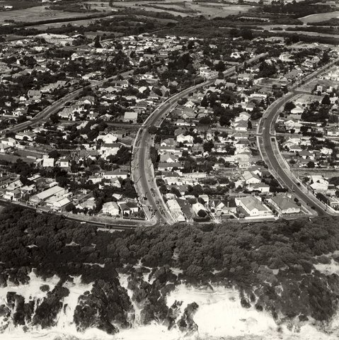
Aerial photo of Black Rock from Jack Holdsworth to AO Backholer to St.Agnes Church. The photo can be dated before 1954, because ads in The Argus for September and October of that year call for tenders to construct Heather Grove, Arkaringa Crescent ROW, Links Street, and portion of Bayview Crescent.
No.60 Arkaringa Crescent, "Clairmont", was built by Clarence Boswell Campbell (see above; photo c. 1950 shows the property, immediately west of the Stafford properties). Mrs Campbell was related to Donald McDonald, an identity of the district.
No.48 Arkaringa Crescent. On 4 November 1933 the National Trustee as executors for the estate of M.A. Ring had auctioned "Lots 2 and 3", Arkaringa Crescent South Side, commencing 150 ft east from Bluff Road, each 54 ft x 140 ft (These were actually Lots 3 and 4 of the Ring Estate – see above). Henry Lees Sercombe bought them and built a house on 48 and as confirmed by the present owners of 48, Matthew and Petra Paton, a tennis court on 46. The tennis court is shown clearly in the photograph c. 1950.
The auction notes state that they had "frontage to a concrete road": Arkaringa Crescent East was one of several experimental roads constructed in the early 1920s using the "cement penetration" method developed by the City of Sandringham Engineer W.T. Sunderland. He patented this method, and it was widely adopted. The c. 1950 photograph shows Arkaringa Crescent East to be a much lighter colour than other streets, indicative of the "concrete road", later covered in bitumen.
")
Another notable house was "Wedgwood", a large estate on the NE corner of Bluff Road and Arkaringa Crescent (see the c. 1950 photograph for a view of this substantial property). Mrs Charlotte Piper, descended from the Wedgwood family, lived there 1892–98. Each room of the house was said to have been painted a different Wedgwood pottery colour (ref: The Street Where You Live, Sandringham Historical Society, 2012). After a long illness Tom Bugler, formerly of Surrey, England, and father of Mrs Piper, died there in 1903. Her husband, Mr Walter George Piper was the first secretary to the Congregational Church established in 1891 at the corner of Arkaringa Crescent and Bent Parade (see also: St Andrews by the Sea). Arthur Hamilton Blaire and Gerte lived there from at least 1916. The estate was subdivided commencing in the mid-1920s and was known as "Blair's Subdivision".
Even to c. 1950 (see the photograph), on the SE corner of Bluff Road and Arkaringa Crescent the Ring property remained much as it was during M.A. Ring's time.
Imposed on each of the transfers of land in the Arkaringa Estate has been a covenant that any rear fence must not face a street, that there must not be any excavation for or the opening up of a sand pit or quarry, and that there must be no noxious trade carried out from any building on the land.
.jpg "Part of MMBW Plan 3195 (190KB)")
.jpg "Part of MMBW Plan 3196(130KB)")
The Owners of Montclair
| Dates | Owners |
| 1927–1964 | Thomas Leslie Stafford married Alice Beryl Clough in 1915. Born in 1892, in 1911
Les Stafford joined Rosella Preserving Co. as
Burroughs adding
machine operator and by 1919 he was Assistant Manager and a Director of the
Company.  He was appointed Managing
Director in 1931. In 1933 the Staffords moved from 3 Montclair Avenue, Brighton, to "Montclair" (the
house they had constructed by builder Mr James Le Ray). The house was located on 62, a putting green
was set on 60A, and later a rose garden was established on 64. The Staffords had adopted two boys,
Stephen and Keith, and later David and Bruce ("Bubbles"), who went to the local Black Rock primary
school which had been erected in 1910. Alice's mother, Eliza Jane Clough (nee Roach), lived at
Montclair probably from the time of her husband's (Frank's) death in 1946, until her death in 1957,
age 90. She occupied bedroom 4, as recollected by Ms Dawn Odgers who each day walked past the
property and waved on her way to and from school. After moving from Montclair to Mont Albert,
Thomas Leslie Stafford died in 1976 aged 84, and Alice Beryl died in 1980, aged 89. Bruce Stafford
is the surviving son and he lives in Scarness, Queensland. Montclair sold for £17,000. He was appointed Managing
Director in 1931. In 1933 the Staffords moved from 3 Montclair Avenue, Brighton, to "Montclair" (the
house they had constructed by builder Mr James Le Ray). The house was located on 62, a putting green
was set on 60A, and later a rose garden was established on 64. The Staffords had adopted two boys,
Stephen and Keith, and later David and Bruce ("Bubbles"), who went to the local Black Rock primary
school which had been erected in 1910. Alice's mother, Eliza Jane Clough (nee Roach), lived at
Montclair probably from the time of her husband's (Frank's) death in 1946, until her death in 1957,
age 90. She occupied bedroom 4, as recollected by Ms Dawn Odgers who each day walked past the
property and waved on her way to and from school. After moving from Montclair to Mont Albert,
Thomas Leslie Stafford died in 1976 aged 84, and Alice Beryl died in 1980, aged 89. Bruce Stafford
is the surviving son and he lives in Scarness, Queensland. Montclair sold for £17,000. |
| 1964–1965 | Priscilla and Dennis Vivian Campbell Tricks lived in Deauville Crescent, bought Montclair and the next year subdivided it into 60A, 62 and 64 Arkaringa Crescent. Their daughter Dr Belinda Tricks recollects that they lived in the house for about six weeks. Dennis was Chair of the Melbourne Stock Exchange and was the son of Frederick George Drake Tricks, Sandringham Town Clerk, who lived from 1938 at 49 Arkaringa Crescent. Dennis remembers Montclair from his childhood time at 49. 60A was bought by Ralph Studdert Higgins and Gwyn Elsie Higgins on 1 June 1965 for £3,700. 64 was bought by Al and Norma Nadalin: it took quite a while for the Nadalins to decide the details of their American style house and it was not until 1967 that they moved in. Meanwhile their son, Paul, and his brother frequently played in Montclair as it stood vacant for a long time and was easily accessible. |
| 1966–1967 | John Hastings Carew-Reid, a vocal businessman, and Patricia Elizabeth Carew-Reid, had two or three children. He used what is the workshop and before that the pool plant room, as a vehicle garage with drive down the west side of the house. The Voters' Roll for 1967 gives for Montclair a NAV $1100 (i.e., CIV $22,000) and UCV $7600. The 1968 Sandringham electoral role list their address as 11 Burgess St., Beaumaris, and his occupation as accountant. |
| 1967–1971 | Charles and Maggie Evans. They bought Montclair for $40,000. Charles was an Amway agent, selling detergents. He had three daughters, Jane, Nickie and Amanda; and a son, Richard, who taught Spanish and collected antique books. Charles told fanciful stories of his past as a British Officer during WW2. He had trouble selling the property for the price he wanted. |
| 1971–1977 | Gavin and Margaret (Peg) Buchanan. He was the Australian(?) representative for Michelin Tyres; they had two boys and three girls, the eldest (Shauna, nurse) about 19 yo by the time they left. They went to NSW central coast and bought a bottleshop. The house sold for "more than $100,000". |
| 1977–1986 |
 Sylvia and Noel Alpins, eye surgeon, have three
daughters. He found the house in very run down condition and undertook many months of highly disruptive
renovation. He built the first version of the carport - council required an open pergola. He had much
of the electrical wiring upgraded, replaced many of the fittings in the house, rebuilt the main
bedroom, extended the family room and installed a bar, rebuilt and updated the kitchen and pantry,
and in early 1980s added an indoor pool and enclosure at the back for his pregnant wife. The pool
room was a very sophisticated setup with air and water heating and humidity control. The old garage
became the pool plant and work room. He also opened up doorways so that the family room is directly
accessible from the dining room, installed the intercom, a wired stereo system, the entrance luminaire,
walkway paths and garden, and raised the front fence. The house sold for $440,000.
Sylvia and Noel Alpins, eye surgeon, have three
daughters. He found the house in very run down condition and undertook many months of highly disruptive
renovation. He built the first version of the carport - council required an open pergola. He had much
of the electrical wiring upgraded, replaced many of the fittings in the house, rebuilt the main
bedroom, extended the family room and installed a bar, rebuilt and updated the kitchen and pantry,
and in early 1980s added an indoor pool and enclosure at the back for his pregnant wife. The pool
room was a very sophisticated setup with air and water heating and humidity control. The old garage
became the pool plant and work room. He also opened up doorways so that the family room is directly
accessible from the dining room, installed the intercom, a wired stereo system, the entrance luminaire,
walkway paths and garden, and raised the front fence. The house sold for $440,000. |
| 1986–1988 | Ian & Helen Moffitt lived at Montclair with two little girls. Ian was CEO of
Australia Card Services. They upgraded the staircase, lounge fireplace and drapes. The dining-room
ceiling has a fruit themed panel border; Helen painstakingly painted each piece of fruit in their
colours. Before, they were (and are now) just a mottled yellow. The house was sold in March for $705,000. |
| 1988–1997 | Joel & Eva Crow. He was an insurance agent for Lloyds and owned a power boat based at Sandringham yacht club and a yacht in Greece. A lovely man who everyone respected. She was Scandanavian, a travel consultant. Joel wanted to put a gable roof on the carport to have it blend with the house but was refused by Council. The metal roof appeared some time after. Eva spent a lot of time in the garden and in home decorating. Many of the window furnishings date from this period. They rented out the house for several years. One family, Mark & Cindy Albers from Canada and then Texas USA, lived here from 1992–94 with their four children. The youngest, Amy, was borne in July 1993 at Cabrini Hospital. They commented (June 2015) that the swimming pool heating system created such high humidity that the wood-lined ceiling of the pool room buckled a lot. The house was sold in March 1997 for $622,500. |
| 1997–2009 |
 Tracey &
Clifford Stoneman. Two sons, Daniel and Mitchell. They installed the Mediterranean slate
courtyard and furnished it with a large stone table and umbrella. Cliff mentioned that he ran the
pool heater once and decided he would need to take another job to pay for it.
Tracey &
Clifford Stoneman. Two sons, Daniel and Mitchell. They installed the Mediterranean slate
courtyard and furnished it with a large stone table and umbrella. Cliff mentioned that he ran the
pool heater once and decided he would need to take another job to pay for it.
 Judging by the number of wiring changes, he evidently had some trouble with the remaining original
electrical circuits which were all in discrete rubber insulated copper.
The house was sold in November 2009 for $1,820,000 at the height of a property price boom.
Judging by the number of wiring changes, he evidently had some trouble with the remaining original
electrical circuits which were all in discrete rubber insulated copper.
The house was sold in November 2009 for $1,820,000 at the height of a property price boom. |
| 2010– | Jannette and Peter Manins. Their previous 35 years were spent at 7 Third Street, Black Rock. The three children all went to Black Rock Primary School, so Jannette was very familiar with and admired Montclair as she often walked past it. Jannette was a qualified Suzuki piano teacher and Peter a Chief Research Scientist in CSIRO in air pollution. |
LINKS
Montclair
")
In 1852 Josiah Morris Holloway purchased Crown Portion 33 for £1 per acre.
")
The Crescents at Black Rock. 17 December 1950. Airspy Collection (Latrobe Library) [S053N07].
")
Enlargement of The Crescents, labelled with streets and buildings. Wedgwood dominates the view, and Arranmore also features. Montclair's distinctive roof line is evident, but Clairmont is obscured by trees.
Arkaringa Crescent (east) stands out as the light-colour road in this c.1940 overhead photo. Montclair, Clairmont, the State Primary School, the Secombe property, Wedgwood, the Ring property - all are clearly shown. The circled properties are the Semco factory and the house of Jack Holdsworth.
")
Montclair. The real estate agent photograph!
")
The street view of Montclair
")
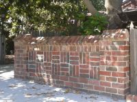
The fence next door shows what the original looked like.

The central window of the Entrance, from the inside of the house, featuring the coat of arms of T L Stafford. Curious: not only are the two Stafford knots inverted, but they are not actually knots!
")
Harry McGain and Morris Minor bread van in Arkaringa Crescent. Montclair in the background with the original fence.
")
A trench dug across Arkaringa Crs for the NBN shows the concrete paving under the bitumen.
All content is Copyright © 2009 Peter Manins - All Rights Reserved. Javascript Menu by Deluxe-Menu.com
LEGAL DISCLAIMER: Everything said on these pages are personal
thoughts and may not be factual or correct and must not be relied upon.
They are NOT recommendations to others.